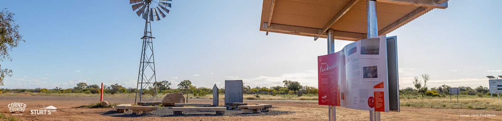
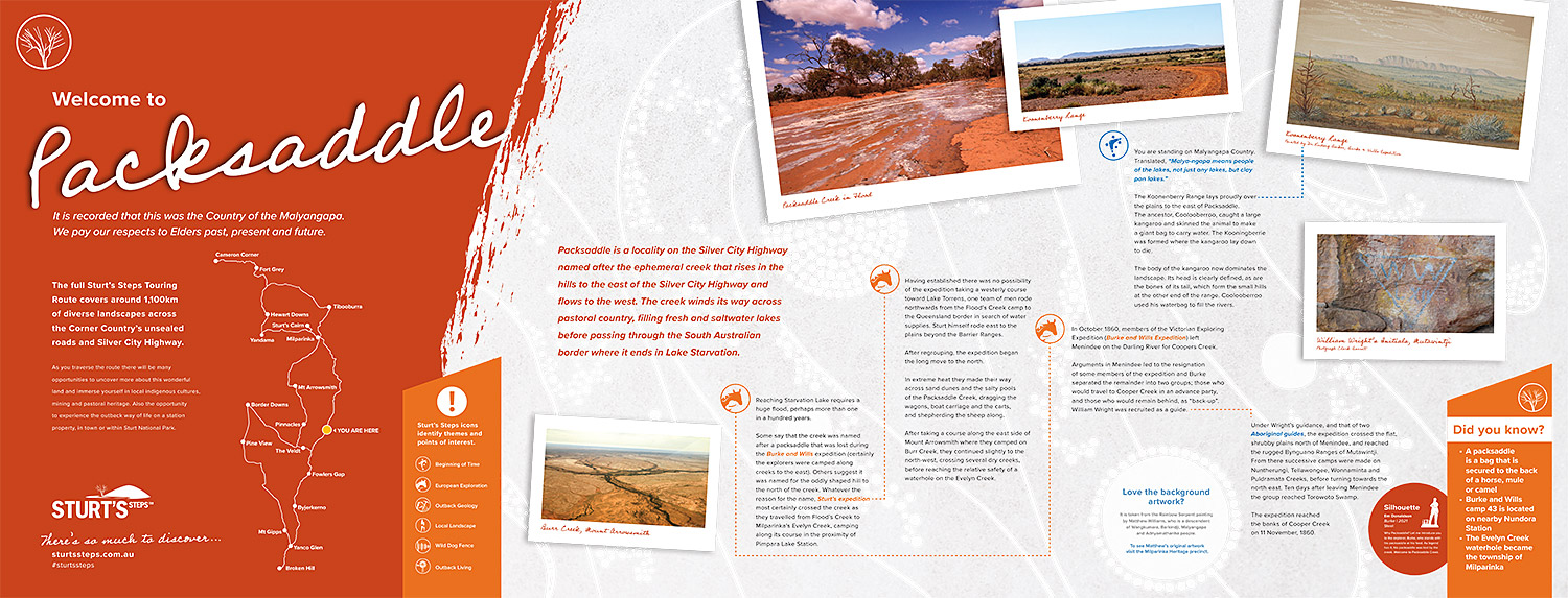
Packsaddle
Welcome to the Packsaddle where the traditional owners are the Malyangapa people. We pay our respects to the elders past, present and emerging.
Landscape
The Packsaddle Creek is an ephemeral watercourse that rises in the hills to the east of the Silver City Highway and flows to the west. It winds its way across pastoral country, filling fresh and saltwater lakes before passing through the South Australian border where it ends in Lake Starvation.
Reaching Starvation Lake requires a huge flood, perhaps more than one in one hundred years.
Some say that the creek was named for a packsaddle that was lost during the Burke and Wills expedition (certainly the explorers were camped along creeks to the east). Others suggest it was named for the oddly shaped hill to the north of the creek. What-ever the reason for the name, Sturt’s expedition most certainly crossed the creek as they travelled from Flood’s Creek to Milparinka’s Evelyn Creek camping along its course in the proximity of Pimpara Lake Station.
Exploration
Sturts Expedition
Having established that there was no possibility of the expedition taking a westerly course toward Lake Torrens, one team of men rode northwards from the Floods Creek camp to the Queensland border in search of water supplies. Sturt himself rode east to the plains beyond the Barrier Ranges. After regrouping, the expedition began the long move to the north.
In extreme heat they made their way across sand dunes and the salty pools of the Packsaddle Creek dragging the wagons and boat carriage and the carts and shepherding the sheep along.
After taking a course along the east side of Mount Arrowsmith they tended slightly north-westerly, and crossed several dry watercourses before reaching the relative safety of a waterhole on the Evelyn Creek.
(Map to show Barrier Ranges, Floods Creek, Packsaddle Creek, Mount Arrowsmith, Evelyn Creek)
Burke and Wills
In October 1860, members of the Victorian Exploring Expedition (Burke and Wills Expedition) left Menindie on the Darling River for Coopers Creek.
Arguments in Menindie led to the resignation of some members of the expedition and Burke separated the remainder into two groups; those who would travel to Cooper Creek in an advance party, and those who would remain behind, as “back-up”. William Wright was recruited as a guide.
Under Wright’s guidance, and that of two Aboriginal guides, the expedition crossed the flat, shrubby plains north of Menindie, and reached the rugged Bynguano Ranges of Mutawintji.
From there successive camps were made on Nuntherungi, Tellawongee, Wonnaminta and Puldramata Creeks, before turning towards the north east. Ten days after leaving Menindie the group reached Torowoto Swamp.
The expedition reached the banks of Cooper Creek on November 11th, 1860.
Did You Know
- A packsaddle is a bag that is secured to the back of a horse, mule or camel
- Burke and Wills camp 43 is located on nearby Nundora Station
- The Evelyn Creek waterhole became the township of Milparinka
Outback living
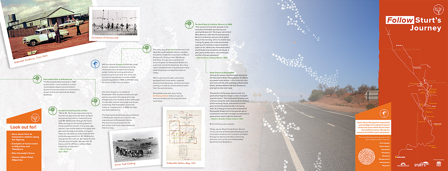
Packsaddle Hotel and Roadhouse
The forerunner to the Packsaddle Roadhouse was the Packsaddle Hotel. Built in 1887 by Alex Scott, it was ideally located on a stock route between Queensland and South Australia to service stockmen, shearers as well as the mail coach to the Albert Goldfields. In 1898 the hotel was destroyed by fire.
The Packsaddle Roadhouse was established in 1958 by Bill Vickers on a site that was originally part of Packsaddle Station. The business has evolved into the well-known and much loved roadhouse that it is today.
Life didn’t always run smoothly at Packsaddle. After drunken brawls amongst patrons resulting in the laying of murder charges after one incident and attempted murder after another, one judge was forced to describe the Packsaddle and similar hotels as “licensed hell”. The same can’t be said of Packsaddle today.
Packsaddle Station
During the early days of pastoral settlement in the West Darling Packsaddle Station included the station properties now known as Mount Arrowsmith, Pimpara Lake, Wyndonga and Yelka. A huge shearing shed was built alongside the Packsaddle Creek at a waterhole named the Duckhole. Boundary riders checked fences around the perimeter while shepherds managed the flocks of sheep.
With no permanent water wells were equipped with a horse works, a geared device driven by horses walking in circle to raise buckets of water from the well.
Packsaddle lease was acquired by Sir Sidney Kidman before it expired and was divided into the properties that exist today.
Look Out For
More about Sturt at interpretive shelters along the highway
Examples of horse-works at Milparinka and Tibooburra