The geology of the area traversed by Charles Sturt’s Central Australian Expedition has been documented in a touring guide written by experienced geologists Bob Brown and Nancy Vickery.
In some detail, travellers to the region can follow the maps and descriptions of the guide to learn and experience yet another fascinating aspect to visitation in the Corner Country. This particular tour also takes in Silverton.
From the guide, “Sturt’s expedition to discover the mythical great inland sea of the hitherto poorly explored Australian continent arrived in the Broken Hill area from Adelaide via Menindee in 1845. The party of men, oxen, sheep, horses and the whaleboat which was to be used for expeditions on the inland sea camped on Stephens Creek (east of what is now Broken Hill) whilst exploring the Barrier Range to the north. The party finally set off to the northwest, crossing the range and then heading northward. A number of large watercourses draining westward from the Barrier Range provided welcome water sources for the thirsty men and animals.
The explorers arrived at a large waterhole on what is now known as Depot Glen in early summer. Hot, dry conditions resulted in the party remaining in this camp for more than 6 months before they set off on further exploration to the north. The party hastily retreated to Menindee in December 1845 after suffering one casualty and enduring unbelievable hardships. Although they failed to discover any inland sea, they were successful in acquiring knowledge on the conditions and geography of this remote region. It was to be almost 15 years before other explorers reached this area, and a further 20 years before the alluvial gold riches of the area about Sturt’s Depot Glen base were discovered.
This geological drive is a reference for those modern explorers who chose to follow the approximate path of Sturt’s expedition. Although it is not feasible to closely follow Sturt’s overland route, a number of gravel roads pass in reasonably close proximity to his passage to and from Depot Glen. The guide provides some insight into the general geology and landforms of the route between Silverton, through Wilangee, Mount Woowoolahra, McDougalls Well, Pine View, Sanpah, Pine Ridge, Yelka, Pimpara Lake, Pincally, Mount Shannon, Mount Browne and finally, Milparinka.
The route is promoted as Sturt’s Steps which is in accordance with a tourism initiative of the Milparinka Heritage and Tourism Association.
The terminology used in the guide is aimed at the layman, although some scientific jargon is inescapable. The route described here comprises gravel roads with local sand drifts, numerous gates, generally no surface water, no commercial fuel outlets, and few, scattered homesteads. Some of these isolated properties offer accommodation or camping. A reliable, appropriate vehicle with an adequate fuel supply is necessary to safely undertake the journey. Adequate food and water, first aid equipment, spare tyres, and emergency communication (satellite phone, UHF radio) are essential. Conventional mobile phones are useless here.
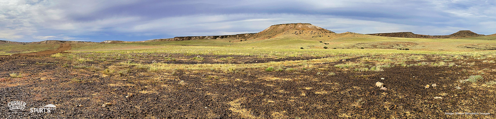
The reward for making the journey is great. The road travels through isolated, largely flat terrain which is dominated by seemingly endless gibber plains and sand dunes. Steep, high ranges of ancient rocks emerge from the plains abruptly, creating awesome backdrops. Mesa-like hills appear in places, capped with tough, erosion-resistant rocks. Camping along the few large creeks or amongst the well vegetated dunes is memorable for the scenery, peace and quiet, and wildlife. Most graziers in this region are welcoming, knowledgeable about their patch of Australia, and replete with tales of the outback. This is a memorable drive which will take you into a part of Sturt’s world, which despite the passing of more than 150 years, retains much of the character and scenery that those hardy explorers would have experienced.
The full Sturt’s Steps geological guide can be downloaded here.
Also available: